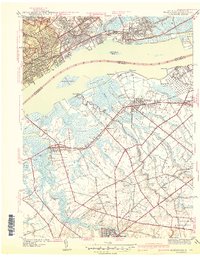
1941 Map of Bridgeport
USGS Topo · Published 1941About this map
Industrial activity and established riverfront life define this Delaware River corridor shortly before the United States entered the Second World War. On the Pennsylvania side, the landscape is heavily developed around Chester, featuring institutional landmarks like the Pennsylvania Military College, Crozer Seminary, and the Locomotive Works. Across the water in New Jersey, the terrain transitions into a mosaic of wetlands and agricultural tracts. Significant marshlands such as Cedar Swamp and Maple Swamp are crisscrossed by a network of creeks and drainage ditches like White Sand Ditch, controlled by Flood Gates. This era shows the massive Hog Island Shipyard already marked as abandoned, a vestige of Great War production. Farther inland in Gloucester County, the map captures the rural character of communities like Swedesboro and Repaupo, where smaller settlements are anchored by local institutions such as Oak Grove Sch and Mt Zion Ch.
Find a feature on this map
77 named features on this map. Tap any name to fly to it.
Don’t see what you’re looking for? This feature index may not catch every label — zoom into the map to look around manually.
Map Details
Editions of this 1941 Bridgeport Map
This is the sole edition of this map. No revisions or reprints were ever made.
Other maps of this area

1890 · Salem
USGS Topo · 1:62,500

1890 · Glassboro
USGS Topo · 1:62,500

1891 · Philadelphia
USGS Topo · 1:62,500

1894 · Chester
USGS Topo · 1:62,500

1894 · Philadelphia
USGS Topo · 1:62,500

1896 · Philadelphia
USGS Topo · 1:62,500

1896 · Chester
USGS Topo · 1:62,500

1898 · Salem
USGS Topo · 1:62,500

1898 · Glassboro
USGS Topo · 1:62,500

1898 · Chester
USGS Topo · 1:62,500