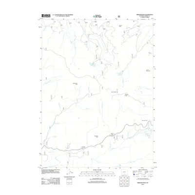
2012 Map of Bridger Peak
USGS Topo · Published 2012About this map
Sierra Madre high-country terrain dominates this portion of Carbon County, where the Continental Divide winds through a landscape defined by significant summits and alpine hydrology. The Edison Monument stands as a notable landmark on the eastern slopes, commemorating Thomas Edison’s visit to the region. Water management and natural drainage patterns are clear throughout the quadrangle, from the engineered Belvidere Ditch to the pristine waters of North Spring Creek Lake and Battle Lake. Numerous peaks, including Bridger Peak, Quartzite Peak, and Vulcan Mountain, provide vertical orientation across a network of seasonal creeks like Haggarty Cr and Jack Cr. Recreational access is centered around remote sites such as Haskins Creek Campground and Lost Creek Campground, which serve as gateways to this high-altitude wilderness.
Find a feature on this map
32 named features on this map. Tap any name to fly to it.
Don’t see what you’re looking for? This feature index may not catch every label — zoom into the map to look around manually.
Map Details
Editions of this 2012 Bridger Peak Map
This is the sole edition of this map. No revisions or reprints were ever made.
Other maps of this area

1932 · Savery
USGS Topo · 1:96,000

1939 · Saratoga
USGS Topo · 1:125,000

1940 · Savery
USGS Topo · 1:125,000

1954 · Rawlins
USGS Topo · 1:250,000

1958 · Rawlins
USGS Topo · 1:250,000

1961 · Red Mountain
USGS Topo · 1:24,000

1961 · Divide Peak
USGS Topo · 1:24,000

1961 · Bridger Peak
USGS Topo · 1:24,000
1961 · Singer Peak
USGS Topo · 1:24,000
1961 · Indian Rocks
USGS Topo · 1:24,000