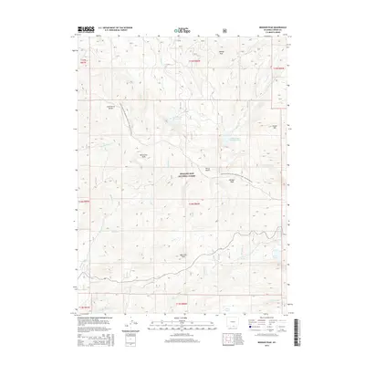
2015 Map of Bridger Peak
USGS Topo · Published 2015About this map
The Sierra Madre range dominates this portion of the Medicine Bow National Forest, where the high-elevation terrain is defined by the Continental Divide. Several prominent summits, including Bridger Peak, Quartzite Peak, and Vulcan Mtn, mark the crest of the divide. The drainage patterns are complex, with headwaters like Haggarty Cr and Battle Cr flowing away from the central ridge. Significant water features such as Battle Lake and the South Spring Creek Reservoir provide notable landmarks within this wilderness area. The Continental Divide National Scenic Trail- Wyoming Portion winds through the landscape, following the spine of the mountains past McCormick Peak and Mowry Peak. This 2015 survey illustrates the modern management of these public lands, noting local infrastructure like the Belvidere Ditch and numerous forest access points.
Find a feature on this map
39 named features on this map. Tap any name to fly to it.
Don’t see what you’re looking for? This feature index may not catch every label — zoom into the map to look around manually.
Map Details
Editions of this 2015 Bridger Peak Map
This is the sole edition of this map. No revisions or reprints were ever made.
Other maps of this area

1932 · Savery
USGS Topo · 1:96,000

1939 · Saratoga
USGS Topo · 1:125,000

1940 · Savery
USGS Topo · 1:125,000

1954 · Rawlins
USGS Topo · 1:250,000

1958 · Rawlins
USGS Topo · 1:250,000

1961 · Red Mountain
USGS Topo · 1:24,000

1961 · Divide Peak
USGS Topo · 1:24,000

1961 · Bridger Peak
USGS Topo · 1:24,000
1961 · Singer Peak
USGS Topo · 1:24,000
1961 · Indian Rocks
USGS Topo · 1:24,000