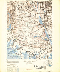
1948 Map of Bridgeton
USGS Topo · Published 1948About this map
The Maurice River and Cohansey River define the industrial and maritime layout of this 1940s landscape, as the towns of Bridgeton, Vineland, and Millville center a complex network of agriculture and industry. Long-established milling sites such as Rammel Mills, Irlands Mills, and Lummis Mill are scattered along the creeks, while the Cumberland and Maurice River Railroad and the West Jersey and Seashore RR facilitate transport toward the Delaware Bay. The map captures the southern New Jersey marshlands and forests in detail, specifically the dense Bear Swamp and the expansive Glades near the coast. Small coastal outposts like Newport, Dividing Creek, and Mauricetown reflect a reliance on the river systems for commerce, situated just above the tidal flats of Dutch Neck and Sayres Neck.
Find a feature on this map
94 named features on this map. Tap any name to fly to it.
Don’t see what you’re looking for? This feature index may not catch every label — zoom into the map to look around manually.
Map Details
Editions of this 1948 Bridgeton Map
3 editions found
Other maps of this area

1888 · Dennisville
USGS Topo · 1:62,500

1890 · Hammonton
USGS Topo · 1:62,500

1890 · Salem
USGS Topo · 1:62,500

1890 · Tuckahoe
USGS Topo · 1:62,500

1890 · Maurice Cove
USGS Topo · 1:62,500

1890 · Bay Side
USGS Topo · 1:62,500

1890 · Bridgeton
USGS Topo · 1:62,500

1890 · Glassboro
USGS Topo · 1:62,500

1891 · Maurice Cove
USGS Topo · 1:62,500

1893 · Tuckahoe
USGS Topo · 1:62,500