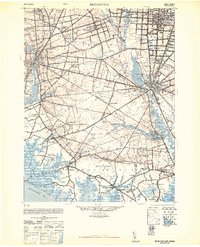
1948 Map of Bridgeton
USGS Topo · Published 1948About this map
Cohansey River and the Maurice River dominate this landscape, illustrating the water-driven development of southern New Jersey. The map details a dense network of milling sites, including Lummis Mill, Shaws Mill, and Rammel Mills, which were central to the local economy before the post-war industrial shift. The settlement pattern reveals distinct historical communities such as Gouldtown and the planned agricultural colony of Rosenhayn.
Find a feature on this map
85 named features on this map. Tap any name to fly to it.
Don’t see what you’re looking for? This feature index may not catch every label — zoom into the map to look around manually.
Map Details
Editions of this 1948 Bridgeton Map
3 editions found
Other maps of this area

1888 · Dennisville
USGS Topo · 1:62,500

1890 · Hammonton
USGS Topo · 1:62,500

1890 · Salem
USGS Topo · 1:62,500

1890 · Tuckahoe
USGS Topo · 1:62,500

1890 · Maurice Cove
USGS Topo · 1:62,500

1890 · Bay Side
USGS Topo · 1:62,500

1890 · Bridgeton
USGS Topo · 1:62,500

1890 · Glassboro
USGS Topo · 1:62,500

1891 · Maurice Cove
USGS Topo · 1:62,500

1893 · Tuckahoe
USGS Topo · 1:62,500