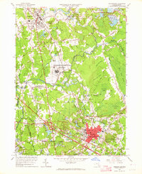
1962 Map of Bridgewater
USGS Topo · Published 1964About this map
The New York New Haven and Hartford railroad cuts through the heart of the landscape, connecting established textile and manufacturing hubs like Bridgewater and Middleboro. In this early 1960s revision, the industrial character of the region is evident in landmarks like Paper Mill Village and the sprawling Massachusetts Correctional Institution near South Bridgewater. The terrain is defined by the winding Taunton River and Nemasket River, which navigate a complex of wetlands including Beaverdam Swamp and Meetinghouse Swamp.
Find a feature on this map
64 named features on this map. Tap any name to fly to it.
Don’t see what you’re looking for? This feature index may not catch every label — zoom into the map to look around manually.
Map Details
Editions of this 1962 Bridgewater Map
3 editions found
Other maps of this area

1885 · Abington
USGS Topo · 1:62,500

1885 · Middleboro
USGS Topo · 1:62,500

1885 · Taunton
USGS Topo · 1:62,500

1886 · Dedham
USGS Topo · 1:62,500

1888 · Taunton
USGS Topo · 1:62,500

1888 · Middleboro
USGS Topo · 1:62,500

1888 · Abington
USGS Topo · 1:62,500

1893 · Abington
USGS Topo · 1:62,500

1893 · Taunton
USGS Topo · 1:62,500

1893 · Middleboro
USGS Topo · 1:62,500