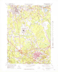
1977 Map of Bridgewater
USGS Topo · Published 1978About this map
Cranberry bogs and wetland complexes define this corner of Plymouth County, where the Taunton River and its numerous tributaries like the Winnetuxet River and Nemasket River converge. The landscape is a mosaic of agriculture and institutional development during the late 1970s, featuring the extensive grounds of the Massachusetts Correctional Institution at South Bridgewater. The rail infrastructure of Conrail links the primary industrial and residential centers of Bridgewater and Middleboro, while smaller historic hamlets such as Paper Mill Village and Warrentown maintain their distinct identities.
Find a feature on this map
73 named features on this map. Tap any name to fly to it.
Don’t see what you’re looking for? This feature index may not catch every label — zoom into the map to look around manually.
Map Details
Editions of this 1977 Bridgewater Map
Other maps of this area

1885 · Abington
USGS Topo · 1:62,500

1885 · Middleboro
USGS Topo · 1:62,500

1885 · Taunton
USGS Topo · 1:62,500

1886 · Dedham
USGS Topo · 1:62,500

1888 · Taunton
USGS Topo · 1:62,500

1888 · Middleboro
USGS Topo · 1:62,500

1888 · Abington
USGS Topo · 1:62,500

1893 · Abington
USGS Topo · 1:62,500

1893 · Taunton
USGS Topo · 1:62,500

1893 · Middleboro
USGS Topo · 1:62,500