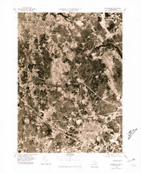
1977 Map of Bridgewater
USGS Topo · Published 1981About this map
The confluence of the Town River and the Taunton River anchors this late-1970s orthophotographic study, revealing the dense woodland and expanding residential patterns of southeastern Massachusetts. This aerial view provides a photographic record of Bridgewater and Middleboro at a time of significant suburban growth. The winding paths of the Nemasket River and Winnetuxet River snake through the landscape, illustrating the riparian environment that historically shaped the placement of local settlements like South Bridgewater and Warrenton. Unlike traditional line maps, this imagery shows the actual forest cover, field boundaries, and road density surrounding North Middleboro, offering researchers a literal view of the land as it existed during the Bicentennial era.
Find a feature on this map
9 named features on this map. Tap any name to fly to it.
Don’t see what you’re looking for? This feature index may not catch every label — zoom into the map to look around manually.
Map Details
Editions of this 1977 Bridgewater Map
Other maps of this area

1885 · Abington
USGS Topo · 1:62,500

1885 · Middleboro
USGS Topo · 1:62,500

1885 · Taunton
USGS Topo · 1:62,500

1886 · Dedham
USGS Topo · 1:62,500

1888 · Taunton
USGS Topo · 1:62,500

1888 · Middleboro
USGS Topo · 1:62,500

1888 · Abington
USGS Topo · 1:62,500

1893 · Abington
USGS Topo · 1:62,500

1893 · Taunton
USGS Topo · 1:62,500

1893 · Middleboro
USGS Topo · 1:62,500