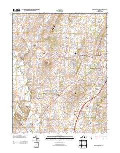
2013 Map of Bridgewater
USGS Topo · Published 2013About this map
Bridgewater and Dayton sit at the heart of this Shenandoah Valley landscape, where the confluence of the North River and Cooks Creek historically shaped local industry and transport. The map reveals a high density of small agricultural settlements and family-run operations such as Byerlys Mill, Willow Spring Dairy, and the Buttermilk Run Poultry Farm, reflecting the region's enduring dairy and milling heritage. Prominent geological features like Mole Hill and Shavers Hill rise above the drainage basins of Muddy Creek and Blacks Run. Transportation patterns are anchored by Frank Field Airport and Jopson Field, while the smaller communities of Mount Clinton, Dale Enterprise, and New Erection illustrate the tight-knit settlement network established long before modern expansion.
Find a feature on this map
253 named features on this map. Tap any name to fly to it.
Don’t see what you’re looking for? This feature index may not catch every label — zoom into the map to look around manually.
Map Details
Editions of this 2013 Bridgewater Map
This is the sole edition of this map. No revisions or reprints were ever made.
Other maps of this area

1892 · Franklin
USGS Topo · 1:125,000

1892 · Woodstock
USGS Topo · 1:125,000

1892 · Harrisonburg
USGS Topo · 1:125,000

1894 · Staunton
USGS Topo · 1:125,000

1896 · Franklin
USGS Topo · 1:125,000

1922 · Fort Seybert
USGS Topo · 1:48,000

1924 · Fort Seybert
USGS Topo · 1:62,500

1941 · Harrisonburg
USGS Topo · 1:62,500

1943 · Harrisonburg
USGS Topo · 1:62,500

1944 · Parnassus
USGS Topo · 1:62,500