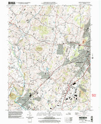
2002 Map of Bridgewater
USGS Topo · Published 2004About this map
Harrisonburg and its surrounding Shenandoah Valley communities are documented in this early 21st-century survey, revealing a landscape defined by collegiate expansion and agricultural tradition. The urban footprint of the city is anchored by the campuses of James Madison University and Eastern Mennonite College, while the southwestern corner of the quadrangle is dominated by Bridgewater College in the town of Bridgewater. Between these centers of education lies a rural network of small settlements such as Dale Enterprise, Stemphleytown, and Montezuma, connected by roads winding through the limestone-influenced terrain.
Find a feature on this map
57 named features on this map. Tap any name to fly to it.
Don’t see what you’re looking for? This feature index may not catch every label — zoom into the map to look around manually.
Map Details
Editions of this 2002 Bridgewater Map
This is the sole edition of this map. No revisions or reprints were ever made.
Other maps of this area

1892 · Franklin
USGS Topo · 1:125,000

1892 · Woodstock
USGS Topo · 1:125,000

1892 · Harrisonburg
USGS Topo · 1:125,000

1894 · Staunton
USGS Topo · 1:125,000

1896 · Franklin
USGS Topo · 1:125,000

1922 · Fort Seybert
USGS Topo · 1:48,000

1924 · Fort Seybert
USGS Topo · 1:62,500

1941 · Harrisonburg
USGS Topo · 1:62,500

1943 · Harrisonburg
USGS Topo · 1:62,500

1944 · Parnassus
USGS Topo · 1:62,500