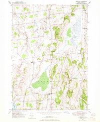
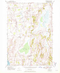
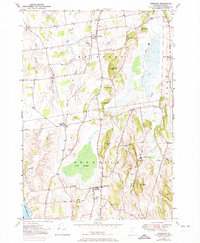
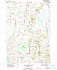
1949 Map of Bridport
USGS Topo · Published 1965About this map
Bridport and Shoreham anchor this mid-century survey of the Champlain Valley, where the landscape is defined by the meandering Lemon Fair River and the complex drainage of Dead Creek. The terrain is characterized by a series of prominent elevations, including Hamilton Hill, Rice Hill, and Mutton Hill, which rise above the surrounding agricultural lands. Notable social landmarks include All Saints Chapel near Cream Hill and St Genevieve Ch in Shoreham village, alongside several burial grounds like Village Cem and the NW Cornwall Cem. The presence of School No 6 and various named brooks such as Potash Brook and Bascom Brook reflects a settled, rural economy integrated with the natural wetlands of Cedar Swamp. This 1949 topography, based on earlier aerial photography and lake surveys, documents the established road network including Lake Shore Road and West Bridport during a period of stable Vermont farm life.
Find a feature on this map
36 named features on this map. Tap any name to fly to it.
Don’t see what you’re looking for? This feature index may not catch every label — zoom into the map to look around manually.
Map Details
Editions of this 1949 Bridport Map
4 editions found
Other maps of this area

1894 · Port Henry
USGS Topo · 1:62,500

1894 · Ticonderoga
USGS Topo · 1:62,500

1896 · Ticonderoga
USGS Topo · 1:62,500

1898 · Port Henry
USGS Topo · 1:62,500

1902 · Ticonderoga
USGS Topo · 1:62,500

1902 · Brandon
USGS Topo · 1:62,500

1903 · Middlebury
USGS Topo · 1:62,500

1904 · Brandon
USGS Topo · 1:62,500

1905 · Middlebury
USGS Topo · 1:62,500

1920 · Brandon
USGS Topo · 1:62,500