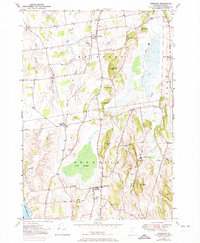
1949 Map of Bridport
USGS Topo · Published 1973About this map
Bridport and Shoreham anchor this agricultural landscape in the mid-20th century, a region defined by its proximity to Lake Champlain and the slow-moving waters of the Lemon Fair River. The map reveals a cluster of rural infrastructure essential to the era, from the prominent St Genevieve Ch and All Saints Chapel to the small rural School No 6 near the Cornwall border. The topography is shaped by a series of low elevations like Mutton Hill and The Pinnacle, which overlook the expansive Cedar Swamp and the branching courses of West Branch Dead Creek and East Branch Dead Creek. This survey, originally compiled in 1949 with 1972 revisions, captures the enduring placement of community landmarks, including numerous family and church burial grounds such as Lakeview Cem and the NW Cornwall Cem.
Find a feature on this map
32 named features on this map. Tap any name to fly to it.
Don’t see what you’re looking for? This feature index may not catch every label — zoom into the map to look around manually.
Map Details
Editions of this 1949 Bridport Map
4 editions found
Other maps of this area

1894 · Port Henry
USGS Topo · 1:62,500

1894 · Ticonderoga
USGS Topo · 1:62,500

1896 · Ticonderoga
USGS Topo · 1:62,500

1898 · Port Henry
USGS Topo · 1:62,500

1902 · Ticonderoga
USGS Topo · 1:62,500

1902 · Brandon
USGS Topo · 1:62,500

1903 · Middlebury
USGS Topo · 1:62,500

1904 · Brandon
USGS Topo · 1:62,500

1905 · Middlebury
USGS Topo · 1:62,500

1920 · Brandon
USGS Topo · 1:62,500