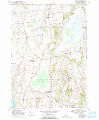
1949 Map of Bridport
USGS Topo · Published 1991About this map
Bridport and Shoreham anchor this agricultural landscape in the Champlain Valley, where the terrain transitions from the low-lying Cedar Swamp to a series of prominent rises including The Pinnacle and Saint George Hill. The 1949 survey illustrates a classic New England settlement pattern of rural hamlets and family-named landmarks. The drainage network is particularly detailed, showing the complex meandering of the Lemon Fair River and the bifurcated Dead Creek with its East and West branches.
Find a feature on this map
36 named features on this map. Tap any name to fly to it.
Don’t see what you’re looking for? This feature index may not catch every label — zoom into the map to look around manually.
Map Details
Editions of this 1949 Bridport Map
4 editions found
Other maps of this area

1894 · Port Henry
USGS Topo · 1:62,500

1894 · Ticonderoga
USGS Topo · 1:62,500

1896 · Ticonderoga
USGS Topo · 1:62,500

1898 · Port Henry
USGS Topo · 1:62,500

1902 · Ticonderoga
USGS Topo · 1:62,500

1902 · Brandon
USGS Topo · 1:62,500

1903 · Middlebury
USGS Topo · 1:62,500

1904 · Brandon
USGS Topo · 1:62,500

1905 · Middlebury
USGS Topo · 1:62,500

1920 · Brandon
USGS Topo · 1:62,500