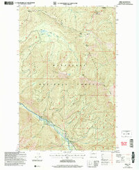
2004 Map of Brief
USGS Topo · Published 2008About this map
The Entiat River carves a deep valley through the Wenatchee National Forest in this 2004 revision, a landscape defined by the towering Chelan Mountains. Small settlements and seasonal locations like Brief and Hazel Camp are situated along the river valley and high passes, marking the sparse human footprint in this high-altitude terrain. The topography is characterized by high alpine basins containing Lower Pawn Lake, Upper Pawn Lake, and Bear Lake, which feed a complex network of drainages including Preston Creek and Brennegan Creek.
Find a feature on this map
45 named features on this map. Tap any name to fly to it.
Don’t see what you’re looking for? This feature index may not catch every label — zoom into the map to look around manually.
Map Details
Editions of this 2004 Brief Map
This is the sole edition of this map. No revisions or reprints were ever made.
Other maps of this area

1899 · Methow
USGS Topo · 1:125,000

1901 · Chelan
USGS Topo · 1:125,000

1901 · Methow
USGS Topo · 1:125,000

1901 · Chiwaukum
USGS Topo · 1:125,000

1902 · Stehekin
USGS Topo · 1:125,000

1904 · Stehekin
USGS Topo · 1:125,000

1904 · Chiwaukum
USGS Topo · 1:125,000

1944 · Lucerne
USGS Topo · 1:62,500

1949 · Lucerne
USGS Topo · 1:62,500

1955 · Concrete
USGS Topo · 1:250,000