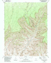
1988 Map of Bright Angel Point
USGS Topo · Published 1988About this map
North Rim serves as the focal point for human activity in this high-altitude section of Grand Canyon National Park during the late 1980s. The landscape is defined by the massive drainage systems of Bright Angel Creek and The Transept, featuring a complex network of named peaks and formations including Manu Temple, Buddha Temple, and Deva Temple. Researchers can trace the established infrastructure of the era, from the Ranger Sta and Campground at the rim to backcountry sites like Cottonwood Camp. The transition from the Walhalla Plateau down into the inner canyon is marked by dramatic water features such as Roaring Springs and the tiered cascades of Ribbon Falls, Upper Ribbon Falls, and Upper Upper Ribbon Falls. This survey documents the primitive transportation routes of the day, specifically the Pack Trail and Foot Trail systems that provided the only access through steep reaches like Haunted Canyon.
Find a feature on this map
58 named features on this map. Tap any name to fly to it.
Don’t see what you’re looking for? This feature index may not catch every label — zoom into the map to look around manually.
Map Details
Editions of this 1988 Bright Angel Point Map
2 editions found
Other maps of this area

1886 · Echo Cliffs
USGS Topo · 1:250,000

1886 · Kaibab
USGS Topo · 1:250,000

1891 · Echo Cliffs
USGS Topo · 1:250,000

1903 · Bright Angel
USGS Topo · 1:48,000

1906 · Bright Angel
USGS Topo · 1:48,000

1907 · Vishnu
USGS Topo · 1:48,000

1953 · Grand Canyon
USGS Topo · 1:250,000

1954 · Nankoweap
USGS Topo · 1:62,500

1956 · Marble Canyon
USGS Topo · 1:250,000

1957 · Grand Canyon
USGS Topo · 1:250,000