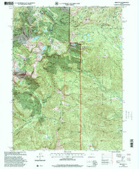
1998 Map of Brighton
USGS Topo · Published 2001About this map
Brighton and its surrounding ski areas anchor this high-elevation landscape, where the recreation economy of the late 20th century sits atop a deep foundation of silver and copper mining. The terrain is marked by an extensive network of 19th-century industrial claims, including the Daly West Mine, Quincy Mine, and Scottish Chief Mine. These sites, along with the Iowa Copper Tunnel and Alta Tunnel, highlight the intensive underground exploration that once defined this portion of the Wasatch Range. Beyond the mining works, the map reveals a sophisticated water management system necessary for both mining and municipal needs, evidenced by Twin Lakes Res and Midway Res. The intersection of Salt Lake, Wasatch, Summit, and Utah counties meeting at these peaks underscores the region's geographic significance as a central watershed.
Find a feature on this map
84 named features on this map. Tap any name to fly to it.
Don’t see what you’re looking for? This feature index may not catch every label — zoom into the map to look around manually.
Map Details
Editions of this 1998 Brighton Map
This is the sole edition of this map. No revisions or reprints were ever made.
Other maps of this area

1885 · Salt Lake
USGS Topo · 1:250,000

1900 · Coalville
USGS Topo · 1:125,000

1903 · Coalville
USGS Topo · 1:125,000

1907 · Strawberry Valley
USGS Topo · 1:125,000

1909 · Strawberry Valley
USGS Topo · 1:125,000

1925 · Ft. Douglas
USGS Topo · 1:125,000

1928 · Ft. Douglas
USGS Topo · 1:125,000

1948 · Timpanogos Cave
USGS Topo · 1:24,000

1948 · Orem
USGS Topo · 1:62,500

1948 · Aspen Grove
USGS Topo · 1:24,000