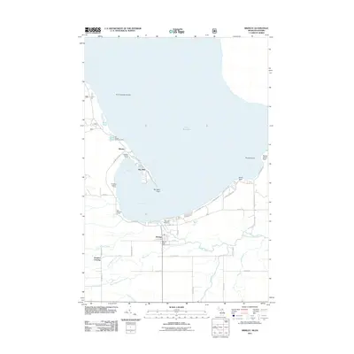
2011 Map of Brimley
USGS Topo · Published 2011About this map
The southern shoreline of Lake Superior dominates this portion of the Upper Peninsula, where the complex hydrology of Waiska Bay and Back Bay meets the mainland. Cultural and tribal history is anchored by the Old Mission Indian Cemetery and the settlement of Mission, situated near Point Iroquois Shoals. Further south, the community of Brimley serves as a local hub, featuring the Brimley Post Office and proximity to the Bayview Cemetery. The landscape is defined by the winding paths of the Waiska River and its various tributaries, including the East Branch Waiska River and Little Waiska Creek. Small landings such as Gordons Landing Ramp and Chippewa Landing Ramp indicate the area's continued orientation toward the water, while interior locations like Dorgans Crossing mark the transition toward the timbered lowlands and creek drainages that feed into the Great Lakes system.
Find a feature on this map
52 named features on this map. Tap any name to fly to it.
Don’t see what you’re looking for? This feature index may not catch every label — zoom into the map to look around manually.
Map Details
Editions of this 2011 Brimley Map
This is the sole edition of this map. No revisions or reprints were ever made.
Other maps of this area

1913 · Sault Sainte Marie
USGS Topo · 1:62,500

1941 · Sault Sainte Marie
USGS Topo · 1:63,360

1941 · Brimley
USGS Topo · 1:63,360

1951 · Shallows
USGS Topo · 1:24,000

1951 · Dollar Settlement
USGS Topo · 1:24,000

1951 · Raco
USGS Topo · 1:24,000

1951 · Kinross
USGS Topo · 1:24,000

1951 · Dafter
USGS Topo · 1:24,000

1951 · Brimley
USGS Topo · 1:62,500

1951 · Sault Ste. Marie
USGS Topo · 1:62,500