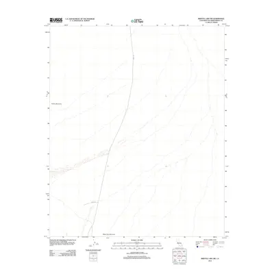
2012 Map of Bristol Lake SW
USGS Topo · Published 2012About this map
Bullion Mountains rise in the northwest, anchoring a landscape defined by the wide alluvial washes of the Mojave Desert. This 2012 survey by the U. S. Geological Survey illustrates a sparse region where human infrastructure is limited to a few arterial passages. The north-south corridor of Amboy Rd serves as the primary transit link through this arid expanse, connecting the distant railway town of Amboy to the southern valleys. Near the southern edge, Ferrell Rd intersects the terrain at the foot of the Sheep Hole Mountains, marking one of the few named landmarks in a territory characterized by complex drainage patterns and shifting desert sands. The map detail highlights the isolation of the basin between these two mountain ranges, providing a record of the road network and topographic contours as they existed in the early 21st century.
Find a feature on this map
4 named features on this map. Tap any name to fly to it.
Don’t see what you’re looking for? This feature index may not catch every label — zoom into the map to look around manually.
Map Details
Editions of this 2012 Bristol Lake SW Map
This is the sole edition of this map. No revisions or reprints were ever made.
Other maps of this area

1942 · Amboy
USGS Topo · 1:250,000

1943 · Amboy
USGS Topo · 1:250,000

1954 · Needles
USGS Topo · 1:250,000

1954 · Bristol Lake NW
USGS Topo · 1:24,000

1954 · Bristol Lake SW
USGS Topo · 1:24,000

1955 · Lead Mtn. NE
USGS Topo · 1:24,000
1955 · Cleghorn Lakes
USGS Topo · 1:24,000

1955 · Lead Mountain
USGS Topo · 1:62,500

1956 · Needles
USGS Topo · 1:250,000

1956 · Dale Lake
USGS Topo · 1:62,500