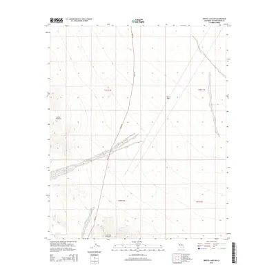
2015 Map of Bristol Lake SW
USGS Topo · Published 2015About this map
The Mojave Desert terrain dominates this 2015 U.S. Geological Survey topographic study, illustrating the convergence of several significant geologic formations in San Bernardino County. In the northwestern quadrant, the Bullion Mountains rise sharply, while the southern edge of the map is defined by the Sheep Hole Mountains. This arid landscape is bisected by N Amboy Rd, which serves as the primary corridor through these dry washes and alluvial fans. The map provides a high-resolution view of the contemporary topography and drainage patterns between these ranges, showing the relationship between the road network and the natural elevation changes in this sparsely populated desert region.
Find a feature on this map
8 named features on this map. Tap any name to fly to it.
Don’t see what you’re looking for? This feature index may not catch every label — zoom into the map to look around manually.
Map Details
Editions of this 2015 Bristol Lake SW Map
This is the sole edition of this map. No revisions or reprints were ever made.
Other maps of this area

1942 · Amboy
USGS Topo · 1:250,000

1943 · Amboy
USGS Topo · 1:250,000

1954 · Needles
USGS Topo · 1:250,000

1954 · Bristol Lake NW
USGS Topo · 1:24,000

1954 · Bristol Lake SW
USGS Topo · 1:24,000

1955 · Lead Mtn. NE
USGS Topo · 1:24,000
1955 · Cleghorn Lakes
USGS Topo · 1:24,000

1955 · Lead Mountain
USGS Topo · 1:62,500

1956 · Needles
USGS Topo · 1:250,000

1956 · Dale Lake
USGS Topo · 1:62,500