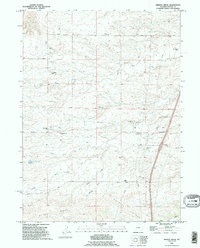
1990 Map of Bristol Ridge
USGS Topo · Published 1995About this map
Family ranching operations and water management dominate this Laramie County landscape, where the Bristol Ridge and Chalk Hill divide the drainage basins of North Bear Creek and South Fork Bear Creek. The mapping reveals a detailed network of private holdings including the Caster Ranch, Elvy Gillespie Ranch, and multiple Duvall family properties such as the Dick Duvall Ranch and Hoyt Duvall Ranch.
Find a feature on this map
30 named features on this map. Tap any name to fly to it.
Don’t see what you’re looking for? This feature index may not catch every label — zoom into the map to look around manually.
Map Details
Editions of this 1990 Bristol Ridge Map
This is the sole edition of this map. No revisions or reprints were ever made.
Other maps of this area

1905 · Sherman
USGS Topo · 1:125,000

1911 · Cheyenne
USGS Topo · 1:125,000

1914 · Cheyenne
USGS Topo · 1:125,000

1954 · Cheyenne
USGS Topo · 1:250,000

1958 · Cheyenne
USGS Topo · 1:250,000

1962 · Dereemer Ranch
USGS Topo · 1:24,000

1962 · Moffett Ranch
USGS Topo · 1:24,000

1962 · Lewis Ranch
USGS Topo · 1:24,000

1962 · Bristol Ridge
USGS Topo · 1:24,000

1962 · Hirsig Ranch
USGS Topo · 1:24,000