
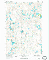
1970 Map of Britton 4 SE
USGS Topo · Published 1973About this map
Fort Sisseton and the surrounding marshlands of northeastern South Dakota dominate this landscape during the early 1970s. This territory, straddling the Marshall and Day County line, is defined by its glacial hydrology, where large water bodies like Stangland Slough and Opitz Lake are surrounded by a dense network of smaller wetlands. The map clearly delineates the Sisseton Military Reservation Boundary, reflecting the region’s long-standing institutional and military history.
Find a feature on this map
11 named features on this map. Tap any name to fly to it.
Don’t see what you’re looking for? This feature index may not catch every label — zoom into the map to look around manually.
Map Details
Editions of this 1970 Britton 4 SE Map
2 editions found
Other maps of this area

1953 · Milbank
USGS Topo · 1:250,000

1958 · Milbank
USGS Topo · 1:250,000

1958 · Britton 4 NW
USGS Topo · 1:24,000

1958 · Britton 4 SW
USGS Topo · 1:24,000

1970 · Eden
USGS Topo · 1:24,000

1970 · Britton 4 NE
USGS Topo · 1:24,000

1970 · Lake City
USGS Topo · 1:24,000

1970 · Roslyn
USGS Topo · 1:24,000

1973 · Lynn Lake
USGS Topo · 1:24,000
1973 · Webster NE
USGS Topo · 1:24,000