
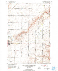
1953 Map of Britton East
USGS Topo · Published 1954About this map
The railroad town of Britton serves as the focal point for this 1950s survey of the Missouri River Basin development area. Located at the intersection of the Great Northern and the C M St P & P rail lines, the community's early mid-century infrastructure is documented through features like the Britton Municipal Airport and the local Sewage Disposal system. The surrounding landscape of Pleasant Valley and Waverly townships is characterized by a network of drainage and water features, including Wild Rice Creek, Crow Creek, and the Gronseth Slough.
Find a feature on this map
24 named features on this map. Tap any name to fly to it.
Don’t see what you’re looking for? This feature index may not catch every label — zoom into the map to look around manually.
Map Details
Editions of this 1953 Britton East Map
2 editions found
Other maps of this area

1953 · Kidder
USGS Topo · 1:24,000

1953 · Newark
USGS Topo · 1:24,000

1953 · Milbank
USGS Topo · 1:250,000

1954 · Kidder SE
USGS Topo · 1:24,000

1956 · Havana
USGS Topo · 1:24,000

1956 · Britton West
USGS Topo · 1:24,000

1958 · Milbank
USGS Topo · 1:250,000

1958 · Spain
USGS Topo · 1:24,000

1958 · Britton 4 NW
USGS Topo · 1:24,000

1970 · Britton 4 NE
USGS Topo · 1:24,000