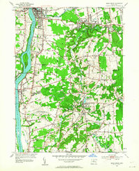
1953 Map of Broad Brook
USGS Topo · Published 1964About this map
The Connecticut River defines the western edge of this landscape, where industrial and agricultural life centered on the water in the mid-1950s. The New York New Haven and Hartford railroad tracks parallel the riverbank, connecting manufacturing hubs like Thompsonville and Warehouse Point. In the interior, the Scantic River powers several local features, including the Broad Brook Millpond and Powder Mill Ponds, signaling the area's legacy of mill-driven industry. Small rural clusters such as Melrose and Scantic are anchored by local institutions like the Scantic Ch and Scantic Cem. Evidence of mid-century leisure and social infrastructure appears in the Drive-in Theater near the southern boundary and the County Home near the river, while the Feltons Pasture State Board of Fisheries indicates early environmental management of the regional wetlands and streams.
Find a feature on this map
73 named features on this map. Tap any name to fly to it.
Don’t see what you’re looking for? This feature index may not catch every label — zoom into the map to look around manually.
Map Details
Editions of this 1953 Broad Brook Map
4 editions found
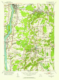
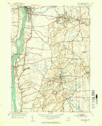
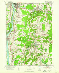
Other maps of this area

1886 · Springfield
USGS Topo · 1:62,500

1887 · Palmer
USGS Topo · 1:62,500

1889 · Springfield
USGS Topo · 1:62,500

1889 · Palmer
USGS Topo · 1:62,500

1892 · Hartford
USGS Topo · 1:62,500

1892 · Tolland
USGS Topo · 1:62,500

1893 · Springfield
USGS Topo · 1:62,500

1893 · Palmer
USGS Topo · 1:62,500

1895 · Springfield
USGS Topo · 1:62,500

1896 · Holyoke
USGS Topo · 1:125,000