
1955 Map of Broad
USGS Topo · Published 1956About this map
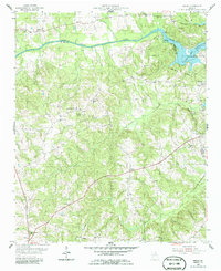
The Broad River defines the landscape of this 1955 survey, where the river's transition into the newly formed Clark Hill Reservoir has begun to reshape the borders of Wilkes, Elbert, and Lincoln counties. The inundation of Anthony Shoals marks a significant change for the region, as the reservoir reservation boundary encloses formerly dry land. Away from the river, the area maintains its traditional agrarian character, centered on a network of small communities and rural congregations such as Shiloh Ch, Popes Chapel, and Friendship Ch. The presence of the Nancy Hart State Park and the eponymous Nancy Hart Highway reflects the local historical significance of the Revolutionary War heroine. Small educational hubs like Pole Branch Sch and crossroads settlements like Delhi and Broad provide valuable geographic markers for genealogical research in this mid-century Georgia backcountry.
Find a feature on this map
36 named features on this map. Tap any name to fly to it.
Don’t see what you’re looking for? This feature index may not catch every label — zoom into the map to look around manually.
Map Details
Editions of this 1955 Broad Map
2 editions found
Other maps of this area

1893 · Elberton
USGS Topo · 1:125,000

1906 · Crawfordville
USGS Topo · 1:125,000

1953 · Athens
USGS Topo · 1:250,000

1954 · Metasville
USGS Topo · 1:24,000

1954 · Greenville
USGS Topo · 1:250,000

1955 · Tignall
USGS Topo · 1:24,000

1955 · Chennault
USGS Topo · 1:24,000

1958 · Greenville
USGS Topo · 1:250,000

1958 · Athens
USGS Topo · 1:250,000

1958 · Elberton
USGS Topo · 1:62,500