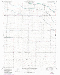
1955 Map of Broadview Farms
USGS Topo · Published 1984About this map
Large-scale irrigation and commercial agriculture define this 1955 landscape in Fresno County, where a complex network of man-made waterways supports extensive ranching operations. The Delta-Mendota Canal sweeps across the northern terrain, supplemented by the Second Canal and Third Canal. These engineering works transformed the valley, allowing for the establishment of the Lyon and Hoag Ranch and Broadview Farms.
Find a feature on this map
25 named features on this map. Tap any name to fly to it.
Don’t see what you’re looking for? This feature index may not catch every label — zoom into the map to look around manually.
Map Details
Editions of this 1955 Broadview Farms Map
3 editions found
Other maps of this area

1913 · Panoche
USGS Topo · 1:125,000

1921 · Tierra Loma School
USGS Topo · 1:31,680

1922 · Oxalis
USGS Topo · 1:31,680

1922 · Dos Palos
USGS Topo · 1:31,680

1922 · Tufts Ranch
USGS Topo · 1:31,680

1922 · Pozo Farm
USGS Topo · 1:31,680

1922 · Chaney Ranch
USGS Topo · 1:31,680

1923 · Wisdom Well
USGS Topo · 1:31,680

1923 · Firebaugh
USGS Topo · 1:31,680

1923 · Tierra Loma School
USGS Topo · 1:31,680