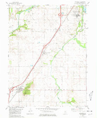
1980 Map of Broadwell
USGS Topo · Published 1981About this map
Elkhart Hill rises as a prominent landmark in this Illinois landscape, overlooking the village of Elkhart and the adjacent Elkhart Slough. The region is defined by a dense concentration of family and community burial grounds, including Elkhart Cem, Latham Cem, and the Development Center Cem located within the Lincoln Development Center (Annex). This 1980s-era survey reveals the established infrastructure of Logan County, where the Illinois Central Gulf railroad and modern highways parallel the natural course of Salt Creek and Lake Fork. The map documents a blend of conservation and utility, featuring the northern reaches of Railsplitter State Park alongside the specialized Lincoln Gas Storage Area, while small settlements like Broadwell and Fogarty anchor the agricultural and transit corridors of the central Illinois prairie.
Find a feature on this map
37 named features on this map. Tap any name to fly to it.
Don’t see what you’re looking for? This feature index may not catch every label — zoom into the map to look around manually.
Map Details
Editions of this 1980 Broadwell Map
This is the sole edition of this map. No revisions or reprints were ever made.
Other maps of this area

1907 · Springfield
USGS Topo · 1:62,500

1911 · Lincoln
USGS Topo · 1:62,500

1913 · Lincoln
USGS Topo · 1:62,500

1930 · Springfield
USGS Topo · 1:62,500

1940 · Springfield
USGS Topo · 1:62,500

1948 · Mason City
USGS Topo · 1:62,500

1949 · Mason City
USGS Topo · 1:62,500

1954 · Mechanicsburg
USGS Topo · 1:62,500

1958 · Peoria
USGS Topo · 1:250,000

1958 · Decatur
USGS Topo · 1:250,000