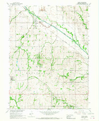
1966 Map of Brock
USGS Topo · Published 1968About this map
The Little Nemaha River snakes across the northern landscape of Nemaha County, anchoring a region defined by agricultural river bottoms and upland homesteads. Near the settlement of Brock, the Missouri Pacific railroad follows the river's path, while further south, the Chicago Burlington and Quincy line passes through Johnson and past the small community of Rohrs. This 1966 field-checked map captures a rural Nebraska landscape punctuated by numerous family-named landmarks and local institutions, including Coryell Chapel and Linden Sch. The presence of an Old Railroad Grade near Johnson provides a clear view of the shifting transportation priorities in the mid-20th century. Scattered quarries and gravel pits across the townships of Lafayette and Washington suggest a local economy tied closely to the land's geology and road-building needs.
Find a feature on this map
29 named features on this map. Tap any name to fly to it.
Don’t see what you’re looking for? This feature index may not catch every label — zoom into the map to look around manually.
Map Details
Editions of this 1966 Brock Map
This is the sole edition of this map. No revisions or reprints were ever made.
Other maps of this area

1903 · Weeping Water
USGS Topo · 1:125,000

1907 · Nebraska City
USGS Topo · 1:62,500

1915 · Howe
USGS Topo · 1:62,500

1929 · Weeping Water
USGS Topo · 1:125,000

1955 · Nebraska City
USGS Topo · 1:250,000

1955 · Lincoln
USGS Topo · 1:250,000

1957 · Nebraska City
USGS Topo · 1:250,000

1957 · Lincoln
USGS Topo · 1:250,000

1958 · Lincoln
USGS Topo · 1:250,000

1958 · Nebraska City
USGS Topo · 1:250,000