
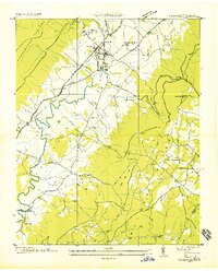
1935 Map of Brockdell
USGS Topo · Published 1935About this map
The Cumberland Plateau landscape of Bledsoe County is defined here by the intricate drainage of Cannon Creek and the Sequatchie River. This 1935 survey, compiled from aerial photographs by the Tennessee Valley Authority and USGS, captures the rural character of the Brockdell settlement during a period of infrastructure expansion. A prominent Tennessee Electric Power Company Transmission Line and the Nashville Transmission Line cut through the terrain, signaling the arrival of industrial-scale electrification to these uplands.
Find a feature on this map
24 named features on this map. Tap any name to fly to it.
Don’t see what you’re looking for? This feature index may not catch every label — zoom into the map to look around manually.
Map Details
Editions of this 1935 Brockdell Map
This is the sole edition of this map. No revisions or reprints were ever made.
Other maps of this area

1888 · Chattanooga
USGS Topo · 1:125,000

1892 · Pikeville
USGS Topo · 1:125,000

1893 · Chattanooga
USGS Topo · 1:125,000

1895 · Pikeville
USGS Topo · 1:125,000

1909 · Sequatchie Valley
USGS Topo · 1:62,500

1910 · Pikeville
USGS Topo · 1:62,500

1935 · Billingsley Gap
USGS Topo · 1:24,000

1935 · Brayton
USGS Topo · 1:24,000

1935 · Mount Airy
USGS Topo · 1:24,000
1935 · Pikeville
USGS Topo · 1:24,000