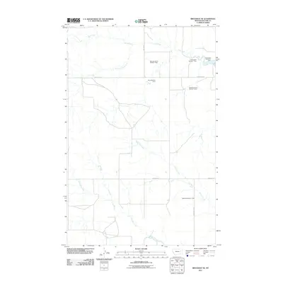
2011 Map of Brockway NE
USGS Topo · Published 2011About this map
Horse Creek and its many tributaries, including the South Fork Horse Creek, define this rural portion of McCone County. In this early twenty-first-century landscape, water management for agriculture is central, as evidenced by a network of private and named reservoirs. Family and farm names are attached to these vital infrastructure points, such as Wheatley Farms Number 1 Dam, Wheatley Farms Number 2 Dam, L Pawlowske Number 1 Dam, and Mathilda Number 1 Dam. The topography is navigated by a sparse grid of gravel and dirt roads like Weldon Rd and Horse Creek Rd, which provide access to these remote ranching areas. In the southern reach, Antelope Creek and Stony Butte Creek further illustrate the seasonal drainage patterns typical of the Montana plains.
Find a feature on this map
14 named features on this map. Tap any name to fly to it.
Don’t see what you’re looking for? This feature index may not catch every label — zoom into the map to look around manually.
Map Details
Editions of this 2011 Brockway NE Map
This is the sole edition of this map. No revisions or reprints were ever made.
Other maps of this area

1954 · Glendive
USGS Topo · 1:250,000

1957 · Glendive
USGS Topo · 1:250,000

1958 · Glendive
USGS Topo · 1:250,000

1982 · Circle
USGS Topo · 1:100,000

1983 · Youngquist Mine
USGS Topo · 1:24,000

1983 · Brockway NE
USGS Topo · 1:24,000

1983 · Haynie Reservoir
USGS Topo · 1:24,000

1983 · North Fork Horse Creek
USGS Topo · 1:24,000
1983 · Brockway
USGS Topo · 1:24,000
1983 · Johnson Coulee East
USGS Topo · 1:24,000