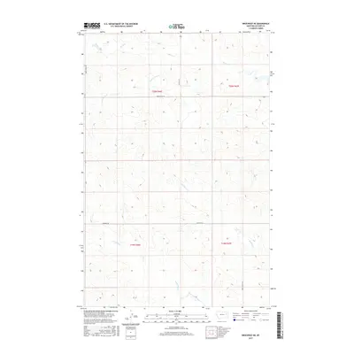
2017 Map of Brockway NE
USGS Topo · Published 2017About this map
McCone County’s undulating prairie landscape is defined by the complex drainage systems of the Big Dry Creek watershed. This 2017 survey details the headwaters and tributaries that carve through the rangeland, including Horse Cr and its secondary branch, S Fork Horse Cr. The map illustrates a remote section of eastern Montana where the township lines of t20n r46e and t20n r47e meet, showing a sparse but vital network of county roads. These thoroughfares, such as Horse Creek Rd and Weldon Rd, follow the natural contours of the land, connecting isolated ranching tracts. Further south, the terrain transitions toward Stony Butte Creek, providing a clear record of the seasonal watercourses and topographic elevations that dictate the movement of livestock and people in this semi-arid environment.
Find a feature on this map
13 named features on this map. Tap any name to fly to it.
Don’t see what you’re looking for? This feature index may not catch every label — zoom into the map to look around manually.
Map Details
Editions of this 2017 Brockway NE Map
This is the sole edition of this map. No revisions or reprints were ever made.
Other maps of this area

1954 · Glendive
USGS Topo · 1:250,000

1957 · Glendive
USGS Topo · 1:250,000

1958 · Glendive
USGS Topo · 1:250,000

1982 · Circle
USGS Topo · 1:100,000

1983 · Youngquist Mine
USGS Topo · 1:24,000

1983 · Brockway NE
USGS Topo · 1:24,000

1983 · Haynie Reservoir
USGS Topo · 1:24,000

1983 · North Fork Horse Creek
USGS Topo · 1:24,000
1983 · Brockway
USGS Topo · 1:24,000
1983 · Johnson Coulee East
USGS Topo · 1:24,000