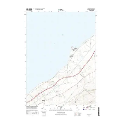
2016 Map of Brocton
USGS Topo · Published 2016About this map
The Lake Erie shoreline defines the character of this Chautauqua County landscape, where the lakefront communities of Van Buren Point and Greencrest sit atop the bluffs of Van Buren Bay. Moving inland, the terrain transitions into the agricultural and residential corridors of Brocton and Portland, historically significant for their position along the transportation routes that parallel the shore. The village of Brocton serves as a central hub, with a dense grid of streets like Central Ave and Main ST connecting to the surrounding rural reaches. Local history is etched into the land at sites like Pecor Cem and the small settlement of Vineyard. Waterways such as Little Canadaway Cr and Slippery Rock Cr carve through the southern hills, illustrating the natural drainage patterns that have influenced settlement from Lamberton to Green Hills for generations.
Find a feature on this map
58 named features on this map. Tap any name to fly to it.
Don’t see what you’re looking for? This feature index may not catch every label — zoom into the map to look around manually.
Map Details
Editions of this 2016 Brocton Map
This is the sole edition of this map. No revisions or reprints were ever made.
Other maps of this area

1899 · Westfield
USGS Topo · 1:62,500

1900 · Dunkirk
USGS Topo · 1:62,500

1943 · Dunkirk
USGS Topo · 1:62,500
1954 · Dunkirk
USGS Topo · 1:24,000
1954 · Brocton
USGS Topo · 1:24,000
1954 · Hartfield
USGS Topo · 1:24,000
1954 · Cassadaga
USGS Topo · 1:24,000
1954 · Westfield
USGS Topo · 1:24,000
1955 · North Of Dunkirk
USGS Topo · 1:24,000

1960 · Buffalo
USGS Topo · 1:250,000