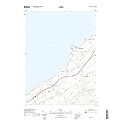
2019 Map of Brocton
USGS Topo · Published 2019About this map
The Chautauqua County shoreline meets the southern reaches of Lake Erie in this detailed survey of New York's grape belt. The landscape is defined by the parallel corridors of the Main St and W Lake Rd, supporting the historic village of Brocton and the town of Portland. The topography reveals the intricate drainage of the region, where waterways like Little Canadaway Creek and Slippery Rock Creek carve their way toward the lake. Small communities and summer colonies such as Van Buren Point, Greencrest, and Vineyard are situated along the coast and rail lines, illustrating the area's long-standing connection to both agriculture and lakefront recreation. Genealogists may find interest in the location of the Pecor Cemetery, while local historians can trace the network of rural routes like Lamberton Road and Chautauqua Road that tie the inland farms to the coastal settlements.
Find a feature on this map
64 named features on this map. Tap any name to fly to it.
Don’t see what you’re looking for? This feature index may not catch every label — zoom into the map to look around manually.
Map Details
Editions of this 2019 Brocton Map
This is the sole edition of this map. No revisions or reprints were ever made.
Other maps of this area

1899 · Westfield
USGS Topo · 1:62,500

1900 · Dunkirk
USGS Topo · 1:62,500

1943 · Dunkirk
USGS Topo · 1:62,500
1954 · Dunkirk
USGS Topo · 1:24,000
1954 · Brocton
USGS Topo · 1:24,000
1954 · Hartfield
USGS Topo · 1:24,000
1954 · Cassadaga
USGS Topo · 1:24,000
1954 · Westfield
USGS Topo · 1:24,000
1955 · North Of Dunkirk
USGS Topo · 1:24,000

1960 · Buffalo
USGS Topo · 1:250,000