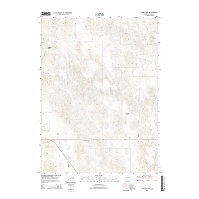
2014 Map of Broken Bow NE
USGS Topo · Published 2014About this map
Broken Bow sits at the southwestern edge of this Custer County landscape, where the town's grid meets the branching drainages of the Nebraska hills. The geography is defined by a series of prominent uplands and depressions, most notably the French Tableland in the northeast and the broad sweeps of Dutchman Valley and Tappan Valley. These landforms dictate the local road network, with routes like Weissert Rd and Round Valley Rd navigating the varying elevations. Waterways including Clear Cr and Mud Cr cut through the terrain, with Deadmans Canyon providing a sharp contrast to the surrounding tablelands. The map illustrates a rural environment shaped by high-plains agriculture and the essential transit corridors, such as Ne-70, that connect this portion of the Sandhills region to the larger county seat.
Find a feature on this map
12 named features on this map. Tap any name to fly to it.
Don’t see what you’re looking for? This feature index may not catch every label — zoom into the map to look around manually.
Map Details
Editions of this 2014 Broken Bow NE Map
This is the sole edition of this map. No revisions or reprints were ever made.
Other maps of this area

1951 · Broken Bow NE
USGS Topo · 1:24,000

1951 · Westerville
USGS Topo · 1:24,000

1951 · Broken Bow SW
USGS Topo · 1:24,000

1951 · Lillian
USGS Topo · 1:24,000

1951 · Ansley
USGS Topo · 1:24,000

1951 · Broken Bow
USGS Topo · 1:24,000

1951 · Broken Bow SE
USGS Topo · 1:24,000

1951 · Round Valley
USGS Topo · 1:24,000

1952 · Sargent SW
USGS Topo · 1:24,000

1955 · Broken Bow
USGS Topo · 1:250,000