
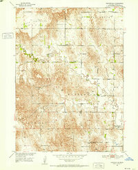
1951 Map of Westerville
USGS Topo · Published 1952About this map
Westerville sits along the southern bends of Clear Creek in this mid-century survey of Custer County. The landscape is defined by the high, flat expanse of the French Tableland to the northwest, which drops away into a network of draws and creek valleys. This era shows a dense rural infrastructure of one-room schoolhouses, such as Cherryvale Sch, Copsey Sch, and Hanna Corners Sch, distributed to serve the farming families in the Westerville and Douglas Grove townships. For genealogists, the map is particularly valuable for locating family burial grounds including French Tableland Cem and Dry Valley Cem, alongside small rural hubs like Weissert and the Pederson Ranch. The distribution of these schools and cemeteries across the townships reflects a settled agricultural community before the consolidation of rural districts.
Find a feature on this map
20 named features on this map. Tap any name to fly to it.
Don’t see what you’re looking for? This feature index may not catch every label — zoom into the map to look around manually.
Map Details
Editions of this 1951 Westerville Map
2 editions found
Other maps of this area

1951 · Broken Bow NE
USGS Topo · 1:24,000

1951 · Ansley
USGS Topo · 1:24,000

1951 · Broken Bow SE
USGS Topo · 1:24,000

1951 · Ansley NE
USGS Topo · 1:24,000

1951 · Round Valley
USGS Topo · 1:24,000

1951 · Ansley SE
USGS Topo · 1:24,000

1952 · Sargent SE
USGS Topo · 1:24,000

1952 · Sargent SW
USGS Topo · 1:24,000

1955 · Broken Bow
USGS Topo · 1:250,000

1956 · Broken Bow
USGS Topo · 1:250,000