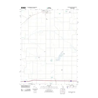
2011 Map of Bronson South
USGS Topo · Published 2011About this map
Bronson stands at the northern edge of this Michigan-Indiana borderland, where the southern portion of the city transitions into a landscape defined by glacial lakes and small rural clusters. This 2011 survey illustrates the settlement patterns of Branch County, with the smaller community of Gilead situated near the shores of Gilead Lake. The terrain is marked by a high density of small burial grounds, including Saint Marys Cemetery, Snow Prairie Cemetery, and the Haight Cemetery, which provide essential touchstones for genealogical research in this border region.
Find a feature on this map
21 named features on this map. Tap any name to fly to it.
Don’t see what you’re looking for? This feature index may not catch every label — zoom into the map to look around manually.
Map Details
Editions of this 2011 Bronson South Map
This is the sole edition of this map. No revisions or reprints were ever made.
Other maps of this area

1940 · Orland
USGS Topo · 1:24,000

1941 · Orland
USGS Topo · 1:24,000

1941 · Angola West
USGS Topo · 1:24,000

1942 · Angola West
USGS Topo · 1:24,000

1947 · Mongo
USGS Topo · 1:24,000

1953 · Fort Wayne
USGS Topo · 1:250,000

1956 · Fort Wayne
USGS Topo · 1:250,000

1960 · Coldwater West
USGS Topo · 1:24,000
1960 · Bronson North
USGS Topo · 1:24,000
1960 · Bronson South
USGS Topo · 1:24,000