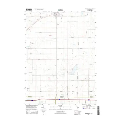
2014 Map of Bronson South
USGS Topo · Published 2014About this map
Bronson stands at the northern edge of this landscape, where the street grid of York St and Compton St gives way to the section-line roads of Branch County. The terrain is defined by its glacial history, with numerous kettle lakes and wetlands including Gilead Lake, Duncan Lake, and Monroe Lake interspersed among the farm plots. In the southern reaches, the Michigan-Indiana state line marks the boundary above Greenfield Reservoir and the Fawn River. This 2014 survey reveals a quiet agricultural and residential pattern where several small burial grounds, such as Saint Marys Cem and Gilead Cem, serve as primary landmarks for local genealogists. The movement of water through the Prairie River and its various tributaries continues to shape the low-lying areas between the township lines of t7s r8w and t8s r7w.
Find a feature on this map
56 named features on this map. Tap any name to fly to it.
Don’t see what you’re looking for? This feature index may not catch every label — zoom into the map to look around manually.
Map Details
Editions of this 2014 Bronson South Map
This is the sole edition of this map. No revisions or reprints were ever made.
Other maps of this area

1940 · Orland
USGS Topo · 1:24,000

1941 · Orland
USGS Topo · 1:24,000

1941 · Angola West
USGS Topo · 1:24,000

1942 · Angola West
USGS Topo · 1:24,000

1947 · Mongo
USGS Topo · 1:24,000

1953 · Fort Wayne
USGS Topo · 1:250,000

1956 · Fort Wayne
USGS Topo · 1:250,000

1960 · Coldwater West
USGS Topo · 1:24,000
1960 · Bronson North
USGS Topo · 1:24,000
1960 · Bronson South
USGS Topo · 1:24,000