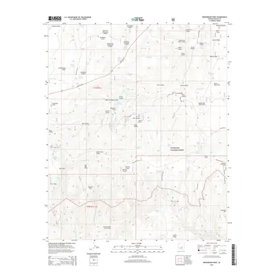
2014 Map of Brookbank Point
USGS Topo · Published 2014About this map
The Mogollon Rim forms a dramatic geographical boundary across this portion of the Sitgreaves National Forest, where the high Mogollon Plateau drops away toward the south. This rugged landscape is defined by a dense network of canyons, including Brookbank Canyon, Turkey Canyon, and Wildcat Canyon, which dissect the limestone and volcanic terrain. Human activity in this high-country environment is evidenced by the presence of the Baca Cem and a complex system of water management features such as Turkey Tank, Twin Tank, and Wilford Spring. Historical access routes like the Mogollon Rim Rd and Chediski Lookout Rd navigate the ridges, while State Hwy 260 provides a modern corridor through the timber. The map details numerous family-named landmarks such as Stermer Ridge and Carrizo Ridge, reflecting the area's history of ranching and forest management on the Navajo County line.
Find a feature on this map
92 named features on this map. Tap any name to fly to it.
Don’t see what you’re looking for? This feature index may not catch every label — zoom into the map to look around manually.
Map Details
Editions of this 2014 Brookbank Point Map
This is the sole edition of this map. No revisions or reprints were ever made.
Other maps of this area

1886 · Holbrook
USGS Topo · 1:250,000

1893 · Holbrook
USGS Topo · 1:250,000

1954 · Holbrook
USGS Topo · 1:250,000

1957 · Holbrook
USGS Topo · 1:250,000

1958 · Holbrook
USGS Topo · 1:250,000

1960 · Holbrook
USGS Topo · 1:250,000

1961 · Woods Canyon
USGS Topo · 1:62,500

1961 · Heber
USGS Topo · 1:62,500

1961 · Chediski Peak
USGS Topo · 1:62,500
1961 · Young
USGS Topo · 1:62,500