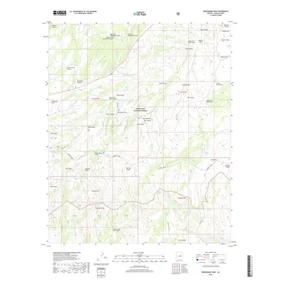
2018 Map of Brookbank Point
USGS Topo · Published 2018About this map
The Mogollon Rim forms a dramatic topographical boundary across this portion of the Sitgreaves National Forest, dictating the flow of numerous seasonal drainages and the placement of early routes. This 2018 survey documents a landscape defined by significant elevation changes, where the historic General Crook trail route winds through the canyons. Notable local landmarks include the Baca Cem and Baca Lake, reflecting the legacy of early ranching families in Navajo County. The complex drainage network is evidenced by the convergence of the West Fork Bull Flat Canyon, Middle Fork Bull Flat Canyon, and East Fork Bull Flat Canyon, while isolated water sources like Turkey Tank and Jersey Tank illustrate the vital water management infrastructure required in this high-country environment. Other significant features like Brookbank Point and Hangmans Draw provide specific geographic anchors for researchers studying this part of Arizona.
Find a feature on this map
80 named features on this map. Tap any name to fly to it.
Don’t see what you’re looking for? This feature index may not catch every label — zoom into the map to look around manually.
Map Details
Editions of this 2018 Brookbank Point Map
This is the sole edition of this map. No revisions or reprints were ever made.
Other maps of this area

1886 · Holbrook
USGS Topo · 1:250,000

1893 · Holbrook
USGS Topo · 1:250,000

1954 · Holbrook
USGS Topo · 1:250,000

1957 · Holbrook
USGS Topo · 1:250,000

1958 · Holbrook
USGS Topo · 1:250,000

1960 · Holbrook
USGS Topo · 1:250,000

1961 · Woods Canyon
USGS Topo · 1:62,500

1961 · Heber
USGS Topo · 1:62,500

1961 · Chediski Peak
USGS Topo · 1:62,500
1961 · Young
USGS Topo · 1:62,500