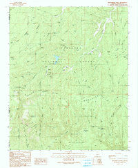
1990 Map of Brookbank Point
USGS Topo · Published 1991About this map
The Mogollon Rim escarpment dominates this portion of the Sitgreaves National Forest, marking the dramatic transition from the high plateau down toward the Fort Apache Indian Reservation. The 1990 landscape is defined by its water management systems, featuring dozens of named stock tanks such as Stump Tank and Wildcat Tank, which supported the region's ranching operations. Human presence is centered around the Gentry Lookout Tower and recreational developments like the Black Canyon Lake Recreation Site.
Find a feature on this map
93 named features on this map. Tap any name to fly to it.
Don’t see what you’re looking for? This feature index may not catch every label — zoom into the map to look around manually.
Map Details
Editions of this 1990 Brookbank Point Map
This is the sole edition of this map. No revisions or reprints were ever made.
Other maps of this area

1886 · Holbrook
USGS Topo · 1:250,000

1893 · Holbrook
USGS Topo · 1:250,000

1954 · Holbrook
USGS Topo · 1:250,000

1957 · Holbrook
USGS Topo · 1:250,000

1958 · Holbrook
USGS Topo · 1:250,000

1960 · Holbrook
USGS Topo · 1:250,000

1961 · Woods Canyon
USGS Topo · 1:62,500

1961 · Heber
USGS Topo · 1:62,500

1961 · Chediski Peak
USGS Topo · 1:62,500
1961 · Young
USGS Topo · 1:62,500