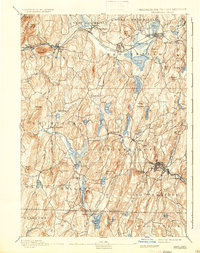
1893 Map of Brookfield
USGS Topo · Published 1936About this map
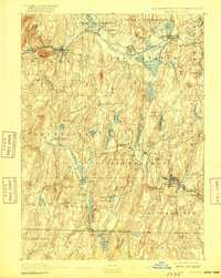
The Quaboag River corridor serves as the industrial and transit spine of this late 19th-century landscape, carrying the Boston and Albany RR through established mill towns like Warren and West Brookfield. The map reveals a region defined by its water power and mineral resources, notably at the settlement of Leadmine near Lead Mine Mountain and Lead Mine Pond. To the southeast, the Quinebaug River anchors the concentrated industrial centers of Southbridge and Sandersdale, while the surrounding uplands are dotted with family-named landmarks such as Foster Hill and Walker Mountain. This survey illustrates the dense network of ponds and reservoirs, including Hamilton Reservoir and Quacumquasit Pond, that supported the local economy before the turn of the century. The southern portion of the sheet captures the rural character of Wales and Holland along the Massachusetts Connecticut Boundary Line.
Find a feature on this map
94 named features on this map. Tap any name to fly to it.
Don’t see what you’re looking for? This feature index may not catch every label — zoom into the map to look around manually.
Map Details
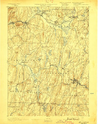
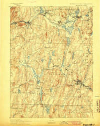
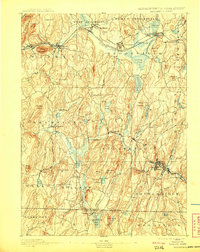
Editions of this 1893 Brookfield Map
7 editions found


Other maps of this area

1885 · Worcester
USGS Topo · 1:62,500

1886 · Worcester
USGS Topo · 1:62,500

1887 · Brookfield
USGS Topo · 1:62,500

1887 · Palmer
USGS Topo · 1:62,500

1887 · Belchertown
USGS Topo · 1:62,500

1887 · Barre
USGS Topo · 1:62,500

1889 · Webster
USGS Topo · 1:62,500

1889 · Putnam
USGS Topo · 1:62,500

1889 · Palmer
USGS Topo · 1:62,500

1889 · Barre
USGS Topo · 1:62,500