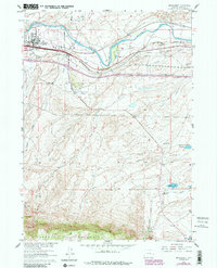
1961 Map of Brookhurst
USGS Topo · Published 1985About this map
The North Platte River carves through this Natrona County landscape, serving as a corridor for industrial development and historical transit. Near Brookhurst, a Refinery and Gravel Pit indicate the mid-century energy and infrastructure growth centered around the Chicago and North Western and Burlington Northern railroads. These modern industrial lines parallel the path of the historic Emigrant Trail, which traces the river's northern bank toward Pearson.
Find a feature on this map
38 named features on this map. Tap any name to fly to it.
Don’t see what you’re looking for? This feature index may not catch every label — zoom into the map to look around manually.
Map Details
Editions of this 1961 Brookhurst Map
3 editions found
Other maps of this area

1949 · Brookhurst
USGS Topo · 1:24,000

1949 · Campbell Hill
USGS Topo · 1:24,000

1949 · Pratts Soda Lakes
USGS Topo · 1:24,000

1950 · Campbell Hill
USGS Topo · 1:24,000

1950 · Lockett
USGS Topo · 1:24,000

1950 · Brookhurst
USGS Topo · 1:24,000

1950 · Pratts Soda Lakes
USGS Topo · 1:24,000

1951 · The Reefs
USGS Topo · 1:24,000

1951 · Casper
USGS Topo · 1:24,000

1955 · Casper
USGS Topo · 1:250,000