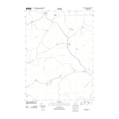
2010 Map of Brookland
USGS Topo · Published 2010About this map
Pine Creek and Ninemile Run define the central drainage of this northern Pennsylvania landscape, where narrow valleys and named hollows dictate the layout of roads and settlements. The map highlights the high-elevation terrain near Triple Divide, a significant geographical point where waters split toward different watersheds. Local recreation and infrastructure are prominent in the southern portion of the quadrangle, which features the Denton Hill Ski Area within Denton Hill State Park and the uniquely named Potato City Airport near the border of Sweden. Smaller hamlets like Brookland, Gold, and Walton are connected by a network of rural routes such as Sweden Hill Rd and Brookland Rd, following the contours of the land. Genealogists and local historians can trace family-named terrain features like Crowell Hollow, Heath Hollow, and Reese Hollow, which provide clues to early land use and settlement patterns in Potter County.
Find a feature on this map
54 named features on this map. Tap any name to fly to it.
Don’t see what you’re looking for? This feature index may not catch every label — zoom into the map to look around manually.
Map Details
Editions of this 2010 Brookland Map
This is the sole edition of this map. No revisions or reprints were ever made.
Other maps of this area

1899 · Gaines
USGS Topo · 1:62,500

1900 · Gaines
USGS Topo · 1:62,500

1932 · Genesee
USGS Topo · 1:62,500

1937 · Genesee
USGS Topo · 1:62,500

1947 · Conrad
USGS Topo · 1:62,500

1947 · Galeton
USGS Topo · 1:62,500

1947 · Ayers Hill
USGS Topo · 1:24,000

1947 · Cherry Springs
USGS Topo · 1:24,000

1947 · Galeton
USGS Topo · 1:24,000
1949 · Ayers Hill
USGS Topo · 1:24,000
Featured Places
- Sweden Township, PA
- Allegany Township, PA
- Raymond, Allegany Township
- Walton, Ulysses Township
- Newfield Junction, Ulysses Township