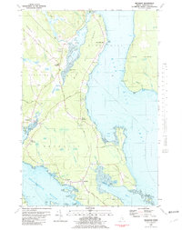
1981 Map of Brooklin
USGS Topo · Published 1981About this map
Blue Hill Bay and the narrow waterway of Eggemoggin Reach define this coastal landscape, where the seafaring heritage of Hancock County is etched into every cove and point. In the early 1980s, the coastline remained dotted with traditional settlements like Brooklin, Haven, and Sedgwick, while the interior was characterized by expansive wetlands such as Long Swamp and Great Heath. The map reveals a high concentration of burial grounds, including the Old Brooklin Cemetery and Mt Ephraim Cemetery, which serve as vital markers for local family histories.
Find a feature on this map
92 named features on this map. Tap any name to fly to it.
Don’t see what you’re looking for? This feature index may not catch every label — zoom into the map to look around manually.
Map Details
Editions of this 1981 Brooklin Map
This is the sole edition of this map. No revisions or reprints were ever made.
Other maps of this area

1934 · Bridgewater
USGS Topo · 1:48,000

1935 · Howe Brook
USGS Topo · 1:48,000

1935 · Presque Isle
USGS Topo · 1:62,500

1936 · Mars Hill
USGS Topo · 1:48,000

1937 · Smyrna Mills
USGS Topo · 1:62,500

1938 · Bridgewater
USGS Topo · 1:62,500

1938 · Houlton
USGS Topo · 1:62,500

1939 · Howe Brook
USGS Topo · 1:62,500

1940 · Mars Hill
USGS Topo · 1:62,500

1951 · Mars Hill
USGS Topo · 1:62,500