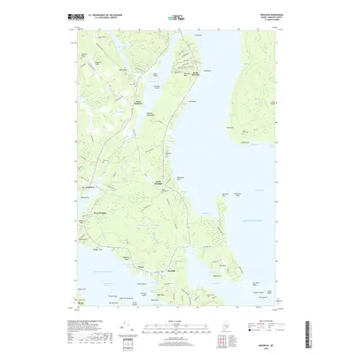
2018 Map of Brooklin
USGS Topo · Published 2018About this map
The coastal peninsula between Blue Hill Bay and Eggeemoggin Reach is defined by a dense network of tidal coves and interior wetlands. Settlements like North Brooklin, West Brooklin, and South Blue Hill are connected by winding coastal roads such as High St and Hales Hill Rd, reflecting a landscape tied closely to the water. The interior topography is marked by significant marshlands including the Great Heath, Black Swamp, and Duck Marsh, which separate the coastal villages. Family history is well-preserved across the peninsula in numerous burial sites, from the Ridge Road Burying Ground in the north to the Freethy Cem near the southern tip at Naskeag Point Rd. These small cemeteries and isolated points like Flye Point and Harriman Point illustrate the decentralized, maritime-oriented settlement pattern of Hancock County's shoreline.
Find a feature on this map
124 named features on this map. Tap any name to fly to it.
Don’t see what you’re looking for? This feature index may not catch every label — zoom into the map to look around manually.
Map Details
Editions of this 2018 Brooklin Map
This is the sole edition of this map. No revisions or reprints were ever made.
Other maps of this area

1904 · Deer Isle
USGS Topo · 1:62,500

1904 · Mount Desert
USGS Topo · 1:62,500

1904 · Swan Island
USGS Topo · 1:62,500

1904 · Bluehill
USGS Topo · 1:62,500

1905 · Penobscot Bay
USGS Topo · 1:125,000

1942 · Mount Desert
USGS Topo · 1:62,500

1942 · Deer Isle
USGS Topo · 1:62,500

1943 · Swans Island
USGS Topo · 1:62,500

1944 · Blue Hill
USGS Topo · 1:62,500

1944 · Deer Isle
USGS Topo · 1:62,500