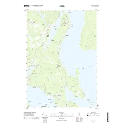
2021 Map of Brooklin
USGS Topo · Published 2021About this map
The Benjamin River and Eggemoggin Reach define this coastal Hancock County landscape, where the seafaring and farming heritage of the Blue Hill Peninsula is preserved in its scattered settlements. The interior is marked by significant wetlands such as Great Heath and Black Swamp, illustrating the complex drainage patterns that lead to tidal inlets like Salt Pond and Center Harbor. For genealogists, the map is particularly rich in family-named locations and burial grounds, including the Old Birchland Cem, Mount Ephraim Cem, and the remote Long Island Cem on the eastern edge of Blue Hill Bay. Local connectivity is shown through historic corridors like Bay Rd and Reach Rd, which link established villages such as North Brooklin, Haven, and West Brooklin to the surrounding coves and points.
Find a feature on this map
131 named features on this map. Tap any name to fly to it.
Don’t see what you’re looking for? This feature index may not catch every label — zoom into the map to look around manually.
Map Details
Editions of this 2021 Brooklin Map
This is the sole edition of this map. No revisions or reprints were ever made.
Other maps of this area

1904 · Deer Isle
USGS Topo · 1:62,500

1904 · Mount Desert
USGS Topo · 1:62,500

1904 · Swan Island
USGS Topo · 1:62,500

1904 · Bluehill
USGS Topo · 1:62,500

1905 · Penobscot Bay
USGS Topo · 1:125,000

1942 · Mount Desert
USGS Topo · 1:62,500

1942 · Deer Isle
USGS Topo · 1:62,500

1943 · Swans Island
USGS Topo · 1:62,500

1944 · Blue Hill
USGS Topo · 1:62,500

1944 · Deer Isle
USGS Topo · 1:62,500