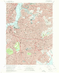
1967 Map of Brooklyn
USGS Topo · Published 1975About this map
The industrial and maritime activity along the East River and Newtown Creek defines the northern edge of this urban study. From the massive infrastructure of the Navy Yard Basin and Wallabout Bay to the rail hubs at Bushwick Junction, the landscape is a dense matrix of 1960s transportation and commerce. Inland, the map reveals the vast spiritual and recreational spaces of the city, dominated by Prospect Park and its central Prospect Lake, alongside several massive burial grounds such as Calvary Cemetery and the Cemetery of the Evergreens. Major institutions serve the growing mid-century population, including the Pratt Institute in Adelphi and the extensive Kings County Hospital complex in East Flatbush. The transition from the high-density neighborhoods of Brooklyn Heights and Williamsburg to the more suburban patterns in Flatlands and Canarsie is captured just before the completion of major expressway expansions, with landmarks like the Williamsburg Bridge and the Long Island Rail Road corridors providing the backbone for the city's movement.
Find a feature on this map
83 named features on this map. Tap any name to fly to it.
Don’t see what you’re looking for? This feature index may not catch every label — zoom into the map to look around manually.
Map Details
Editions of this 1967 Brooklyn Map
4 editions found
Other maps of this area

1888 · Paterson
USGS Topo · 1:62,500

1889 · Brooklyn
USGS Topo · 1:62,500

1891 · Brooklyn
USGS Topo · 1:62,500

1891 · Harlem
USGS Topo · 1:62,500

1892 · Paterson
USGS Topo · 1:62,500

1897 · Harlem
USGS Topo · 1:62,500

1897 · Brooklyn
USGS Topo · 1:62,500

1898 · Harlem
USGS Topo · 1:62,500

1898 · Staten Island
USGS Topo · 1:62,500

1898 · Brooklyn
USGS Topo · 1:62,500