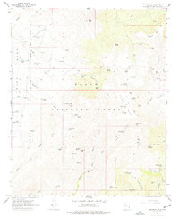
1967 Map of Brooklyn Peak
USGS Topo · Published 1977About this map
Tonto National Forest lands dominate this mid-century survey of the Arizona interior, where high plateaus like Perry Mesa and Hutch Mesa are dissected by a complex network of canyons and washes. The high point of Brooklyn Peak overlooks a landscape defined by cattle ranching and scattered mining prospects. Evidence of human habitation is sparse and functional, consisting of isolated outposts such as Crockett Cabin, Wright Cabin, and Hogan Cabin.
Find a feature on this map
71 named features on this map. Tap any name to fly to it.
Don’t see what you’re looking for? This feature index may not catch every label — zoom into the map to look around manually.
Map Details
Editions of this 1967 Brooklyn Peak Map
3 editions found
Other maps of this area

1887 · Verde
USGS Topo · 1:250,000

1887 · Prescott
USGS Topo · 1:250,000

1892 · Verde
USGS Topo · 1:250,000

1892 · Prescott
USGS Topo · 1:250,000

1903 · Bradshaw Mountains
USGS Topo · 1:125,000

1929 · Turret Peak
USGS Topo · 1:125,000

1933 · Turret Peak
USGS Topo · 1:125,000

1947 · Bumblebee
USGS Topo · 1:62,500

1947 · Mayer
USGS Topo · 1:62,500

1948 · Bumblebee
USGS Topo · 1:63,360