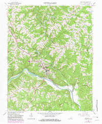
1966 Map of Brookneal
USGS Topo · Published 1981About this map
The Roanoke River serves as the focal point of this Southside Virginia landscape, marking the convergence of Campbell, Halifax, and Charlotte counties. The town of Brookneal stands as a primary hub where the Norfolk and Western railway lines intersect, supporting a mix of local industry including a Filtration Plant and Fish Hatchery. Of significant local interest is the presence of Red Hill (Home of Patrick Henry), the final home and burial place of the founding father, situated along the river's northern bank.
Find a feature on this map
43 named features on this map. Tap any name to fly to it.
Don’t see what you’re looking for? This feature index may not catch every label — zoom into the map to look around manually.
Map Details
Editions of this 1966 Brookneal Map
3 editions found
Other maps of this area

1892 · Lynchburg
USGS Topo · 1:125,000

1892 · Appomattox
USGS Topo · 1:125,000

1947 · Roanoke
USGS Topo · 1:250,000

1953 · Greensboro
USGS Topo · 1:250,000

1954 · Greensboro
USGS Topo · 1:250,000

1954 · Halifax
USGS Topo · 1:62,500

1954 · Riceville
USGS Topo · 1:62,500

1956 · Brookneal
USGS Topo · 1:62,500

1956 · Gladys
USGS Topo · 1:62,500

1959 · Roanoke
USGS Topo · 1:250,000