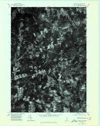
1975 Map of Brooks NW
USGS Topo · Published 1980About this map
North Dixmont and Dixmont serve as the primary hubs in this orthophotoquad, which utilizes 1975 aerial photography to document the rural landscape of Penobscot County. The map provides a high-contrast visual record of the region's agricultural patterns and woodlots before significant late-century development. Moving westward, the crossroads of Hows Corners and East Troy are clearly visible, illustrating the traditional settlement patterns of central Maine. The terrain is defined by the prominent Mount Harris and the winding course of Martin Stream in the northeast. This specialized photographic survey offers an unfiltered view of property lines, forest clearing, and road networks, capturing the transition between the small village centers of Troy and the surrounding timber and farm country during the mid-1970s.
Find a feature on this map
7 named features on this map. Tap any name to fly to it.
Don’t see what you’re looking for? This feature index may not catch every label — zoom into the map to look around manually.
Map Details
Editions of this 1975 Brooks NW Map
This is the sole edition of this map. No revisions or reprints were ever made.
Other maps of this area

1926 · Burnham
USGS Topo · 1:62,500

1930 · Pittsfield
USGS Topo · 1:48,000

1931 · Stetson
USGS Topo · 1:48,000

1932 · Brooks
USGS Topo · 1:62,500

1932 · Pittsfield
USGS Topo · 1:62,500

1933 · Pittsfield
USGS Topo · 1:62,500

1935 · Stetson
USGS Topo · 1:62,500

1948 · Bangor
USGS Topo · 1:250,000

1955 · Pittsfield
USGS Topo · 1:62,500

1955 · Brooks
USGS Topo · 1:62,500