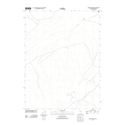
2011 Map of Brooks Spring
USGS Topo · Published 2011About this map
Ryegrass Ranch serves as a lone human waypoint in this high-desert region of Humboldt County, established in a landscape defined by seasonal water flow and vital springs. The 2011 survey by the U.S. Geological Survey details the hydrology of the area, centered on the intermittent Ragan Creek which carved the local drainage patterns. Vital water sources like Sulphur Spring and Brooks Spring suggest the critical nature of reliable water in this arid environment, providing the necessary conditions for ranching and survival in the Great Basin. The map's sparse settlement pattern reflects the enduring isolation of the Nevada interior, where the relationship between geology and life is governed by these few scattered springs.
Find a feature on this map
4 named features on this map. Tap any name to fly to it.
Don’t see what you’re looking for? This feature index may not catch every label — zoom into the map to look around manually.
Map Details
Editions of this 2011 Brooks Spring Map
This is the sole edition of this map. No revisions or reprints were ever made.
Other maps of this area

1932 · Sonoma Range
USGS Topo · 1:250,000

1939 · Sonoma Range
USGS Topo · 1:250,000

1940 · Antler Peak
USGS Topo · 1:62,500

1943 · Antler Peak
USGS Topo · 1:62,500

1955 · Winnemucca
USGS Topo · 1:250,000

1958 · Winnemucca
USGS Topo · 1:250,000

1962 · Winnemucca
USGS Topo · 1:250,000

1965 · Knight
USGS Topo · 1:24,000

1965 · Goldrun Creek
USGS Topo · 1:24,000
1965 · Golconda
USGS Topo · 1:24,000